Monday, January 21, 2019

A Close Encounter with COL Mosby's Pistol

Back in 2013 while attending a reunion of Mosby's Rangers descendants in Middleburg, VA I had the pleasure of meeting Don Hakenson, author of several historical books on the Rangers. Turns out, we are distant cousins with Baldwin Lunsford as our common ancestor.


A docent at the Stuart-Mosby Cavalry Museum, he also leads bus tours of sites around Mosby's Confederacy.  The very next weekend he was to be at the museum for a bus tour. "If you can get there extra early before the bus leaves I can let you hold Mosby's pistol".

I said whaaaaaat?


Needless to say, I was there well before any of the tour patrons arrived. No way was I going to miss out on this opportunity to actually hold a Mosby historical artifact. This pistol was donated to the museum by the Mosby family. But I'm sure he had more than one as the Rangers were known to carry a whole bag of Colt 1860s when raiding.

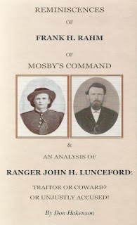
Don's book on Ranger Frank Rahm and a more detailed analysis of the Cobbler Mountain artillery incident involving John H. Lunceford is an excellent read.


On the way back from the museum I followed Don's directions to John's grave in Delaplane (Piedmont Station), VA.


R. Dwayne Lunsford, PhD


Saturday, January 19, 2019

Baldwin Ridge on Lunsford Mountain


From 1607 until the Revolution, the Church of England reigned supreme in Virginia second only to the General Assembly in terms of political power . Besides fostering the numinous life of everyday Virginians, the local parish took care of what we today would consider basic social services; care of the poor, orphans, widows, bastard children, etc. In some of the other colonies this also included overseeing essential services like road construction. Parishioners were actually taxed for not attending service. How times have changed!

Hamilton Parish was established in 1730. The first Episcopal church was built in Warrenton in 1816. Colonial times were harsh and mother churches often established "chapels-of-ease". These were more accessible satellite churches for folks living outside of town or on the frontier. They often couldn't attend service because of the travel distances involved and/or the impassable nature of dirt roads in the winter.

Christ's Chapel on Baldwin's Ridge was one such chapel-of-ease. Completed in 1883 as a "mission" church of St. James Church, it functioned until 1941 but eventually was razed in the 1950s.  The exact location was on Mate's Hill, part of Lunsford's Mountain a prominent hill that begins just outside of town, briefly parallels US15, 29 & 211 and then crosses this road at New Baltimore. From there it becomes Pound Mountains before finally joining the ridge of Bull Run Mountain at Thoroughfare Gap.

"Baldwin" ridge? "Lunsford's Mountain"? "Close geographic proximity to Bull Run Mountain"? Simple coincidence? Who knows. But after wondering about this place for years I finally had to do a recon. Right after our annual family Christmas breakfast in Manassas (2018) we decided to scope this place out. The Find-a-Grave entry showed a new sign for the cemetery that was improved as an Eagle Scout project. That seemed to indicate that there still were graves there. Because of the establishment date (1883) I didn't expect to find Baldwin's grave but where there any other Lunsfords buried there?

No coordinates or street address was provided on Find-a-Grave so we began by turning off US29 onto Baldwin St. (how appropriate). After spending about twenty minutes taking back road turns to ascend and parallel the ridge we found the cemetery sign right along Baldwin Ridge Rd. (at least they are consistent).


It was a bit weathered, so the Find-a-Grave picture must have been taken right after the Eagle Scout completed his service project several years ago. The cemetery is situated on a narrow strip between the road and a housing development. Besides the history sign board (see top) there was the ubiquitous Periwinkle we see on so many abandoned country grave sites in northern Virginia. Also visible were signs of an old cast-iron fence, many unmarked graves and this one example of a marker.


Heading home we continued south to the intersection with Dumfries Rd. (SR605). This road is historical, having been one of the first colonial roads in Virginia, essential for the transport of tobacco and other goods from the Shenandoah Valley and Piedmont to the once viable port of Dumfries.

One other Lunsford connection; just south-west of this area, lying between Meetze and Old Auburn roads, is a short piece of paved road called "Lunsford Rd".

So the question remains; is there any connection between these geographical locations and our little branch of the Lunsford family? Avenues of future research will require combing through land ownership records for these areas and perhaps the parish records from St. James Church. Only time will tell.

R. Dwayne Lunsford, PhD


Monday, January 14, 2019

That Little Old Cabin in Halfway

The Halfway Cabin in 2014 (click for larger img.)

Welcome to the inaugural posting for "Bull Run Mountain Memories"! This blog will cover the life and times of the Lunceford/Lunsford families believed to be derived from one Baldwin Lunsford (born abt. 1764) of Fauquier County Virginia. He is our earliest known ancestor. This is a work in progress and meant to be a replacement for my circa 2001 web site The Lunsfords; Six Generations and Counting. Soon to come will be an updated surname directory and family tree for our immediate lines as well as photo and document archives. There also will be a separate page on DNA testing. So bookmark and stay tuned!

In 2001, I was fortunate to be introduced to Beverly Aiken (nee Lunceford) of Havana, KS. Her father, James Shelby Lunceford, Sr. (died in 1964, son of Samuel Shelton Lunceford, grandson of my Great-great grandfather, Elijah Chilton Lunceford) claimed to have visited Elijah's cabin in 1962. We assume this was Elijah's cabin as her family's oral tradition claimed that Samuel was born there. I was intrigued! From recent oral histories we knew that the ancestral homelands for our branch of the family centered around the Halfway, Marshall and The Plains areas of Fauquier County in the shadow of Bull Run Mountain. But no one seemed to know anything about an extant cabin remaining in Halfway with a connection to Elijah.

Beverly returned to the area in 2003 with the hope of revisiting the cabin; entering the property just as they did back in 1962 through the field behind Long Branch church (just off SR626). From her report they didn't walk back very far and seeing a pile of rocks concluded that the house had been razed. But curiosity was killing me and in the winter of 2014 (to take advantage of dead underbrush), me, my dad and his cousin mounted an expedition. For us, the back field behind the church didn't look all that accessible so we drove down the driveway to the side of the church. This led to several houses and farms. At the end of that road we came to a little house with the owner in the yard. After introducing ourselves and what we were after he pointed to the woods just across his meadow. "Is that what you are looking for?"It was like an epiphany. Right there in the trees at the bottom of a wooded knoll was the house that matched Beverly's pictures from 1962!

A well developed private driveway ascended the knoll on the edge of the property. We drove back there for a look but except for a small lake there were no structures. A side path from that driveway went directly to the cabin. There were several dry lay stone walls (including a neat retaining wall around back), a stone cairn, a spring and pond (flowing well), but no other obvious structures. The house had been white washed and it appeared to be recently fixed up a bit. A power meter box looked new on the side and there was evidence of modern insulation being added to the attic and then removed. It was as if someone had planned to move in but changing their mind at the last minute. There was no sign of a new power line to feed the house or method of sewage disposal.

Comparisons between the 2014 pictures and 1962 scans provided by Beverly
Approach from the modern driveway


Approach from the Long Branch church side


Door and stairs to the attic. Rear ground level door to the right


Ridge poles and log detail in attic


This is a log cabin with a textured sheet metal covering that matched the 1962 photos. Although somewhat open to the elements, the roof was intact and except for a rickety porch, overall it was in really good shape considering its apparent age. During the 1800s the forest to the sides and rear most likely was meadow. I checked this area closely for signs of other structures. Nothing was obvious but there were some stone traces that may have been very shallow footers to a shed or small barn.

Stone cairn on the path toward the cabin from the private driveway


Chimney
This services both the main fireplace on the second floor as well as the small fireplace in the basement

Rear view from top of retaining wall

Retaining wall around backyard
Note steps incorporated into the lay facilitating access to what would have been the rear meadow
Could this be Lunsford stone work?

Rear view from top of knoll

Small cemetery over the top of the knoll
~ 500 yrds from the house
approximately four graves but only one marked with a headstone

The single marker
CSA veteran's stone for George H. Smith
Co. C, 8th VA Infantry
Elijah is noteworthy as having been a member of Co. E, 43rd VA CAV CSA (Mosby's Men). Family oral tradition tells that his primary job was horse thief to help supply the Rangers and to send the extras to Richmond for the war effort. As a child, my grandfather (Ernest Chilton Lunsford Sr.) knew this man in life. He would relate the tale that at one point COL Mosby told Elijah to go climb a tree and look out for the Yankees whereby he was shot through the ear. Of the two pictures I have of him only his left ear is visible and that one appears intact. 

We have no way of knowing if the cemetery over the back hill was associated with the occupants of the cabin. But after reading a first draft of this post, Tim Lunceford recalled seeing a genealogical connection to George H. Smith in his tree. Apparently Smith's daughter, Madie Ann Smith married Elijah's son John Henry Lunceford. Three of Elijah's sons left Virginia for Missouri as adults; Samuel Shelton, John Henry and William Rhodes Lunceford. Samuel and William went out first followed by John after he married Madie Smith. Also of note, in the 1870 and 1880 census, George Smith is listed as a stone mason.

Final Notes

Could this really be Elijah's cabin? According to Beverly, "My dad always felt like this was the house he was looking for because he remembered his dad and his Uncle John [John Henry Lunceford] saying the 2nd floor was ground level in the back and the front door ground level in the front". But did Elijah actually own this property or live there at any time? I suspect the only way to tell for sure is to do a detailed search of the land records. 

Census records and a death certificate describe Elijah as a farmer. Family oral tradition tells us that he also was a "Waller"; a stonemason who could build dry lay stone walls without mortar. These are common around the fields of rural Fauquier County and one could imagine that almost any farmer of the time might construct these as part of their field clearing efforts. The stone work on the foundation and chimney as well as the surrounding dry walls were first rate. However, the support pilings for the front porch were amateurish to say the least. I'm no architect, but I suspect that as a log cabin, the porch either was added later or replaced in modern times. Besides the poor quality of the stone work on the pilings this was evident in the modern era framing boards of the porch. The fact that an active spring and pool were on the property was note worthy. As was the large stone cairn. It is not clear what the function of that cairn might have been. It was dry lay not just a simple pile of stones. It took some artistic effort to build.

Was the Smith family neighbors just over the hill? Or did they have a closer association with the cabin in some way? Landlords perhaps, or vice versa? Hopefully a detailed study of the land records for this area will clarify the association between the two families.

As an aside, in 2018 Tim Lunceford discovered a National Register document for the Little River Rural Historic District. On page-104, the Logan's Mill ruin (circa 1830) is described on Barton's Branch of Little River situated a third of a mile east of stone Bridge #6233. This area is further down SR626 on the outskirts of Middleburg, VA. The intact miller's house is said to be banked within a cleared hillside; a square, one and one-half story single cell structure built into the hillside and surrounded with various dry stone walls. The document goes on to state that this was a common way for early Virginian industrialists to accommodate the rolling elevations of the natural landscape.

After leaving the Logan family this industrial property was first sold in 1869 to Elijah C. Lunceford for $716 and later resold in 1875 to a neighboring farmer, Samuel Craig. It is interesting to note that a Samuel Craig along with Bailey Crain and James Crain were witnesses to Baldwin Lunceford's will in 1847.

R. Dwayne Lunsford, PhD